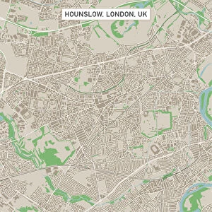
Home > Europe > United Kingdom > England > London > Boroughs > Hounslow
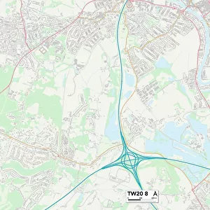
Hounslow TW4 7 Map

![]()
Wall Art and Photo Gifts from Map Marketing
Hounslow TW4 7 Map
Postcode Sector Map of Hounslow TW4 7
Media ID 19980066
Ashton Gardens Badger Close Belgrave Road Cambridge Close Cambridge Road Cedar Road Clare Road Clifford Road Cranbrook Road Dale Avenue Ermine Close Ferndale Avenue Francis Road Haslemere Avenue Hounslow Ivanhoe Road Lancaster Place Logan Close Maitland Close Manor Avenue Martindale Road Old Farm Close Osborne Road Ravensdale Road Rectory Road Renfrew Road Rosemary Avenue Selwyn Close Solway Close Squirrel Close St Dunstans Road Standard Road Stansfield Road The Greenway Toad Lane Trinity Close Vincent Road Wilton Road Windsor Road
FEATURES IN THESE COLLECTIONS
> Animals
> Amphibians
> Toads
> Nearctic Toads
> Green Toad
> Animals
> Mammals
> Muridae
> Toad Mouse
> Animals
> Mammals
> Mustelidae
> Sable
> Animals
> Mammals
> Squirrel
> Arts
> Artists
> P
> Francis Place
> Europe
> United Kingdom
> England
> London
> Boroughs
> Hounslow
> Map Marketing
> Postcode Sector Maps
> TW - Twickenham
> Maps and Charts
> Related Images
MADE IN THE USA
Safe Shipping with 30 Day Money Back Guarantee
FREE PERSONALISATION*
We are proud to offer a range of customisation features including Personalised Captions, Color Filters and Picture Zoom Tools
SECURE PAYMENTS
We happily accept a wide range of payment options so you can pay for the things you need in the way that is most convenient for you
* Options may vary by product and licensing agreement. Zoomed Pictures can be adjusted in the Cart.