Home > Europe > United Kingdom > England > London > Towns > Hounslow
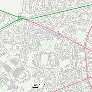
Hounslow London UK City Street Map

![]()
Wall Art and Photo Gifts from Fine Art Storehouse
Hounslow London UK City Street Map
Vector Illustration of a City Street Map of Hounslow, London, UK. Included files are EPS (v10) and Hi-Res JPG.
Data courtesy from Ordnance Survey: VectorMap District
https:/ordnancesurvey.co.uk/business-and-government/products/vectormap-district.html
OS OpenData is free to use under the Open Government Licence (OGL).
Contains OS data eCrown copyright and database right 2017.
http:/nationalarchives.gov.uk/doc/open-government-licence/version/3/
Unleash your creativity and transform your space into a visual masterpiece!
Frank Ramspott
Media ID 15054981
© Frank Ramspott, all rights reserved
Aerial View Computer Graphic Directly Above Gray Green London Road Map Street Map Text Digitally Generated Image Hounslow
FEATURES IN THESE COLLECTIONS
> Aerial Photography
> Related Images
> Arts
> Contemporary art
> Digital artwork
> Street art
> Arts
> Portraits
> Pop art gallery
> Street art portraits
> Arts
> Street art graffiti
> Digital art
> Digital paintings
> Arts
> Street art graffiti
> Digital art
> Vector illustrations
> Europe
> United Kingdom
> England
> London
> Boroughs
> Hounslow
> Europe
> United Kingdom
> England
> London
> Towns
> Hounslow
> Europe
> United Kingdom
> Maps
> Fine Art Storehouse
> Map
> Street Maps
> Maps and Charts
> Related Images
EDITORS COMMENTS
This print showcases a detailed and visually stunning city street map of Hounslow, London, UK. Created using vector illustration techniques, this artwork provides an intricate representation of the bustling streets and roads that make up this vibrant city. The included files in EPS (v10) and Hi-Res JPG formats ensure high-quality reproduction for various purposes. The data used to create this map is courtesy of Ordnance Survey: VectorMap District, a trusted source known for its accuracy and reliability. This valuable resource is made available under the Open Government Licence (OGL), allowing free usage while respecting copyright laws. With its impressive cartography design and digitally generated image, this print captures the essence of Hounslow's urban landscape without any human presence. The color scheme features shades of gray, green, blue, and white to enhance readability and provide a pleasing aesthetic appeal. From an aerial view directly above the city streets, this artwork offers a unique perspective on Hounslow's physical geography. Whether you are an admirer of maps or simply appreciate fine art with a touch of modernity, Frank Ramspott's creation will surely captivate your imagination.
MADE IN THE USA
Safe Shipping with 30 Day Money Back Guarantee
FREE PERSONALISATION*
We are proud to offer a range of customisation features including Personalised Captions, Color Filters and Picture Zoom Tools
SECURE PAYMENTS
We happily accept a wide range of payment options so you can pay for the things you need in the way that is most convenient for you
* Options may vary by product and licensing agreement. Zoomed Pictures can be adjusted in the Cart.