Home > Asia > Pakistan > Maps
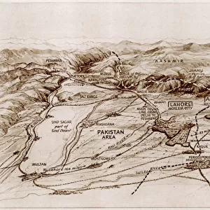
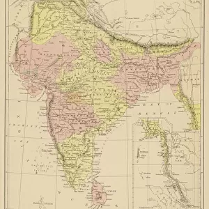
Proposed partition map of India and Pakistan

![]()
Wall Art and Photo Gifts from Mary Evans Picture Library
Proposed partition map of India and Pakistan
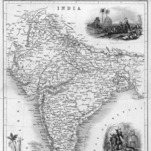
A map of India showing the suggested area of Pakistan - an independent state for Muslims in a free India. The shaded area shows the provinces forming the basis of Pakistan, as proposed by the Muslim League. Date: 1946
Mary Evans Picture Library makes available wonderful images created for people to enjoy over the centuries
Media ID 14379766
© Illustrated London News Ltd/Mary Evans
1946 Jan16 League Muslim Pakistan Partition Proposed Suggested
FEATURES IN THESE COLLECTIONS
> Asia
> India
> Related Images
> Asia
> Pakistan
> Related Images
> Maps and Charts
> India
> Maps and Charts
> Related Images
EDITORS COMMENTS
This historic map, dated 16th January 1946, represents a pivotal moment in the political evolution of South Asia. The shaded areas on the map depict the proposed partition of India, outlining the regions that were to form the independent Muslim state of Pakistan. The Muslim League, under the leadership of Muhammad Ali Jinnah, had long advocated for a separate homeland for Muslims in undivided India. The partition of India and the creation of Pakistan were the result of years of communal tensions and political negotiations. The idea of a separate Muslim state gained momentum after the Lahore Resolution of 1940, which called for the establishment of an independent state for Muslims in South Asia. The proposed partition map shows the areas that were to become part of Pakistan, with the eastern and western wings separated by the vast expanse of what is now Bangladesh. The provinces of Punjab, Sindh, Balochistan, and North-West Frontier Province were the main areas of focus for the Muslim League, as they had large Muslim populations. The partition of India and the creation of Pakistan in 1947 brought about immense upheaval and tragedy, with millions of Hindus and Muslims displaced from their homes. The division of families, communities, and historical sites was a painful process, one that continues to shape the region's political and social landscape. This map serves as a reminder of the complex history of the Indian subcontinent and the profound impact of the partition on its people. It is a testament to the enduring legacy of the Muslim League and the political vision of its leaders, who sought to create a separate homeland for Muslims in a free India.
MADE IN THE USA
Safe Shipping with 30 Day Money Back Guarantee
FREE PERSONALISATION*
We are proud to offer a range of customisation features including Personalised Captions, Color Filters and Picture Zoom Tools
FREE COLORIZATION SERVICE
You can choose advanced AI Colorization for this picture at no extra charge!
SECURE PAYMENTS
We happily accept a wide range of payment options so you can pay for the things you need in the way that is most convenient for you
* Options may vary by product and licensing agreement. Zoomed Pictures can be adjusted in the Cart.