Home > Arts > Artists > G > Louis Guillaume
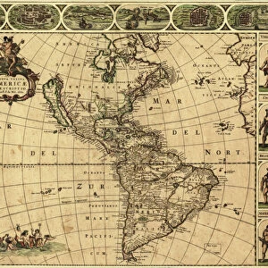
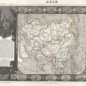
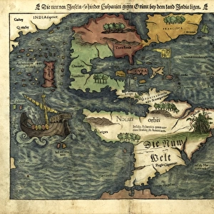
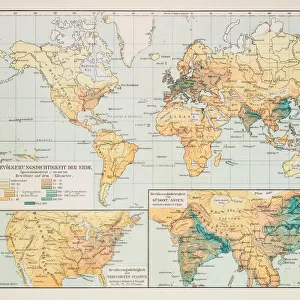
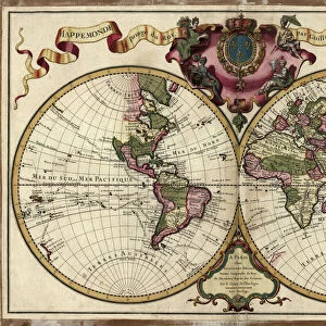
Map of the world, 1720

![]()
Wall Art and Photo Gifts from Fine Art Storehouse
Map of the world, 1720
(Original Caption) 18th century map of the world. Published in Paris in 1720, this French map shows the known world, including the new lands that had been discovered in the preceding centuries by Europeans exploring across the Atlantic and far to the East around Africa. It divides the Earth into a western and eastern hemisphere, and uses colour to mark different areas of land. The map is by Guillaume de l Isle (1675-1726), the leading French cartographer of the eighteenth century. He was appointed Premier Geographe du Roi to King Louis XV in 1718. This edition of his world map includes the western and northern coastlines of Australia, mapped by the Dutch. Australias eastern coastline would not be mapped until 1770
Unleash your creativity and transform your space into a visual masterpiece!
Library of Congress, Geography and Map Division
Media ID 13431689
© This content is subject to copyright
18th Century 18th Century Style Americas Asian Colonialism Colony Continent Dutch Empire Eurasia Eurasian Exploration French Geographic Geographical Geography Medieval New World North America North American Old World South American Spanish The Americas World Colonies Continental Eastern Asian
FEATURES IN THESE COLLECTIONS
> Africa
> Related Images
> Africa
> South Africa
> Maps
> Africa
> South Africa
> Related Images
> Animals
> Mammals
> Muridae
> Western Mouse
> Arts
> Art Movements
> Medieval Art
> Arts
> Artists
> G
> Louis Guillaume
> Asia
> Related Images
> Europe
> France
> Canton
> Landes
> Europe
> France
> Paris
> Maps
> Fine Art Storehouse
> Map
> Historical Maps
EDITORS COMMENTS
This 18th-century map of the world, published in Paris in 1720, offers a glimpse into the expanding knowledge and exploration of Europeans during that era. Created by Guillaume de l'Isle, one of the most esteemed French cartographers of his time, this map showcases the known world at that point in history. Divided into western and eastern hemispheres, this intricately detailed map reveals the new lands discovered by European explorers across the Atlantic and around Africa. It highlights different areas using vibrant colors to distinguish between continents and regions. Notably, this edition includes the western and northern coastlines of Australia as mapped by Dutch explorers. However, it is interesting to note that Australia's eastern coastline would not be charted until several decades later in 1770. As we observe this historical artifact from Library of Congress' Geography and Map Division collection, we are reminded of an era marked by colonialism and empire-building. This map symbolizes both scientific progress and geopolitical ambitions as nations sought to expand their influence across distant lands. With its wealth of information about ancient civilizations, geographical features, colonies, trade routes, and more - all presented through exquisite cartography - this print serves as a testament to humanity's insatiable curiosity for discovery. It invites us on a journey through time while reminding us how far our understanding has come since those early days of exploration.
MADE IN THE USA
Safe Shipping with 30 Day Money Back Guarantee
FREE PERSONALISATION*
We are proud to offer a range of customisation features including Personalised Captions, Color Filters and Picture Zoom Tools
SECURE PAYMENTS
We happily accept a wide range of payment options so you can pay for the things you need in the way that is most convenient for you
* Options may vary by product and licensing agreement. Zoomed Pictures can be adjusted in the Cart.