Home > Science Photo Library > Aerial and Satellite
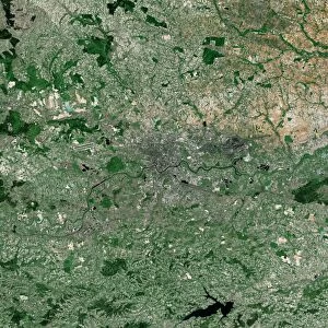
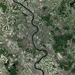
Paris, France, satellite image

![]()
Wall Art and Photo Gifts from Science Photo Library
Paris, France, satellite image
Paris, France. Satellite image of the city of Paris (centre) and its surrounding area in north-central France. North is at top. The Seine River is seen running through the city from bottom right to top left. Forested areas are dark green, agricultural fields are lighter shades of green and brown, urban areas are grey, and water is black. Image created using NaturalVue data obtained from the Landsat 7 satellite
Science Photo Library features Science and Medical images including photos and illustrations
Media ID 1705007
© EARTH SATELLITE CORPORATION/SCIENCE PHOTO LIBRARY
Capital City Earth Observation Farm Land Field Fields Forest Forests France French From Space Landsat 7 Nasa Natural Colour Naturalvue River Satellite Satellite Image Urban Urbanisation Urbanization Vegetation Wood Land Seine River
EDITORS COMMENTS
This satellite image showcases the stunning city of Paris, France, and its surrounding area in all its glory. The photograph provides a bird's-eye view of this iconic European capital, revealing the intricate geography and natural beauty that make it truly unique. At first glance, one cannot help but be drawn to the majestic Seine River meandering through the heart of the city. Its graceful curves create a mesmerizing contrast against the urban landscape. As we explore further, we notice dark green patches representing lush forests and woodlands that surround Paris like protective guardians. The lighter shades of green and brown depict vast agricultural fields stretching out into the distance, symbolizing France's rich farming heritage. These fertile lands contribute to both sustenance and scenic charm. Urban areas are characterized by their grey hue, showcasing Paris' bustling streets and architectural wonders that have captivated visitors for centuries. From famous landmarks such as the Eiffel Tower to charming neighborhoods like Montmartre, every corner tells a story steeped in history and culture. In this image taken from space using NaturalVue data obtained from Landsat 7 satellite by NASA Earth Observation program, we gain an appreciation for how human civilization has harmoniously blended with nature in this vibrant metropolis. It serves as a reminder of our ability to coexist with our environment while creating breathtaking landscapes cherished by millions worldwide.
MADE IN THE USA
Safe Shipping with 30 Day Money Back Guarantee
FREE PERSONALISATION*
We are proud to offer a range of customisation features including Personalised Captions, Color Filters and Picture Zoom Tools
SECURE PAYMENTS
We happily accept a wide range of payment options so you can pay for the things you need in the way that is most convenient for you
* Options may vary by product and licensing agreement. Zoomed Pictures can be adjusted in the Cart.