Home > Europe > United Kingdom > England > London > Towns > Isle of Dogs
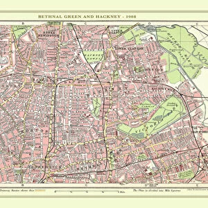
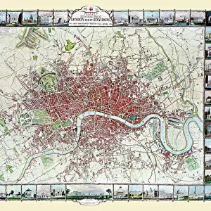
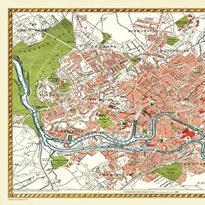
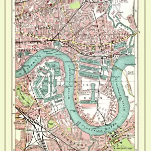
Old Street Map of The Isle of Dogs and River Thames at Greenwich 1908

![]()
Wall Art and Photo Gifts from MapSeeker
Old Street Map of The Isle of Dogs and River Thames at Greenwich 1908
Detailed colour Street Plan of London from 1908 covering the area around The Isle of Dogs and The River Thames at Greenwich.The image has been remastered from Bartholomews Handy Atlas of London and Suburbs 1908
Welcome to the Mapseeker Image library and enter an historic gateway to one of the largest on-line collections of Historic Maps, Nostalgic Views, Vista's and Panorama's from a World gone by.
Media ID 20347636
© Mapseeker Publishing Ltd, Collins Bartholomew Ltd
London Map London Street Plan Map Of Central London Map Of London Old London Street Map Old Map Of London Central Street Map Of London Street Plan Greenwich Isle Of Dogs
FEATURES IN THESE COLLECTIONS
> Arts
> Photorealistic artworks
> Detailed art pieces
> Masterful detailing in art
> Europe
> United Kingdom
> England
> London
> Boroughs
> Greenwich
> Europe
> United Kingdom
> England
> London
> River Thames
> Europe
> United Kingdom
> England
> London
> Towns
> Greenwich
> Europe
> United Kingdom
> England
> London
> Towns
> Isle of Dogs
> Maps and Charts
> Related Images
> MapSeeker
> British Town And City Plans
> English & Welsh PORTFOLIO
EDITORS COMMENTS
This print takes us back in time to the bustling streets of London in 1908. The old street map of The Isle of Dogs and River Thames at Greenwich provides a detailed glimpse into the city's rich history. Remastered from Bartholomews Handy Atlas, this vibrant image showcases the intricate network of roads, buildings, and landmarks that once defined this area. As we explore the map, we are transported to a bygone era where horse-drawn carriages traversed cobblestone streets and gas lamps illuminated the way. Every corner is filled with fascinating details, capturing the essence of life in early 20th century London. The Isle of Dogs stands out as a hub of activity with its thriving docks and industrial sites. Meanwhile, along the meandering River Thames at Greenwich, we can imagine majestic ships sailing past iconic landmarks such as Cutty Sark and Greenwich Park. John Bartholomew's expertise shines through in this meticulously crafted street plan. Collins BartholomewMapseeker Publishing has done an exceptional job remastering this piece of history for all to enjoy. Whether you're a history enthusiast or simply intrigued by London's past, this old street map offers a unique perspective on how much our beloved city has evolved over time. It serves as a reminder that beneath today's modern metropolis lies layers upon layers of stories waiting to be discovered.
MADE IN THE USA
Safe Shipping with 30 Day Money Back Guarantee
FREE PERSONALISATION*
We are proud to offer a range of customisation features including Personalised Captions, Color Filters and Picture Zoom Tools
SECURE PAYMENTS
We happily accept a wide range of payment options so you can pay for the things you need in the way that is most convenient for you
* Options may vary by product and licensing agreement. Zoomed Pictures can be adjusted in the Cart.