Home > Aerial Photography > Related Images
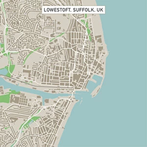
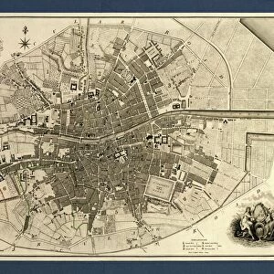
Broken Arrow Oklahoma US City Street Map
![]()
Wall Art and Photo Gifts from Fine Art Storehouse
Broken Arrow Oklahoma US City Street Map
Vector Illustration of a City Street Map of Broken Arrow, Oklahoma, USA. Scale 1:60, 000.
All source data is in the public domain.
U.S. Geological Survey, US Topo
Used Layers:
USGS The National Map: National Hydrography Dataset (NHD)
USGS The National Map: National Transportation Dataset (NTD)
Unleash your creativity and transform your space into a visual masterpiece!
Frank Ramspott
Media ID 15215774
© Frank Ramspott, all rights reserved
Aerial View City Map Computer Graphic Directly Above Downtown District Gray Oklahoma Road Map Text Digitally Generated Image Green Color White Color
FEATURES IN THESE COLLECTIONS
> Aerial Photography
> Related Images
> Animals
> Insects
> Hemiptera
> Green Scale
> Arts
> Contemporary art
> Digital artwork
> Street art
> Arts
> Landscape paintings
> Waterfall and river artworks
> River artworks
> Arts
> Portraits
> Pop art gallery
> Street art portraits
> Arts
> Street art graffiti
> Digital art
> Digital paintings
> Arts
> Street art graffiti
> Digital art
> Vector illustrations
> Fine Art Storehouse
> Map
> Street Maps
> Fine Art Storehouse
> Map
> USA Maps
> Maps and Charts
> Geological Map
> Maps and Charts
> Related Images
> North America
> United States of America
> Lakes
> Related Images
EDITORS COMMENTS
This print showcases a meticulously detailed vector illustration of the city street map of Broken Arrow, Oklahoma, USA. With a scale of 1:60,000, every intricate aspect of this vibrant city is beautifully depicted. The source data used for this artwork is in the public domain and comes from the U. S. Geological Survey's National Hydrography Dataset (NHD) and National Transportation Dataset (NTD), ensuring accuracy and reliability. The image captures the essence of Broken Arrow's downtown district with its bustling streets, surrounded by stunning natural elements such as lakes and rivers. The road network intricately weaves through the city, providing a comprehensive view of its urban layout. This visually appealing map serves as an invaluable tool for navigation or simply admiring the artistry behind cartography. Digitally generated with precision and attention to detail, this aerial view offers a unique perspective directly above Broken Arrow. The color palette blends shades of gray, blue, white, and green seamlessly to create an aesthetically pleasing composition that will enhance any space it adorns. With no people present in the image itself but filled with text indicating important landmarks and areas within Broken Arrow, this print effortlessly combines both artistic design and practical functionality. Created by Frank Ramspott exclusively for Fine Art Storehouse using state-of-the-art computer graphics techniques ensures top-notch quality that will captivate viewers' imagination while celebrating the physical geography of this remarkable city.
MADE IN THE USA
Safe Shipping with 30 Day Money Back Guarantee
FREE PERSONALISATION*
We are proud to offer a range of customisation features including Personalised Captions, Color Filters and Picture Zoom Tools
SECURE PAYMENTS
We happily accept a wide range of payment options so you can pay for the things you need in the way that is most convenient for you
* Options may vary by product and licensing agreement. Zoomed Pictures can be adjusted in the Cart.