Home > Asia > Iran > Lakes > Caspian Sea
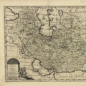
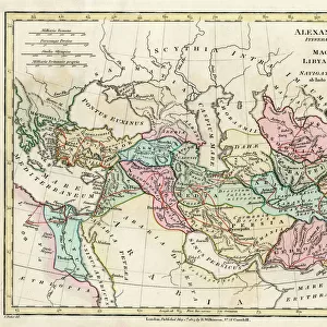
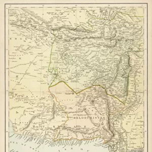
Political map of South Western Asia

![]()
Wall Art and Photo Gifts from Heritage Images
Political map of South Western Asia
Political map of South Western Asia. Map of the Near and Middle East, showing parts of East Africa and the Arabian Peninsula. Plate 50 from The Times Atlas
Heritage Images features heritage image collections
Media ID 15464840
© The Print Collector / Heritage-Images
Afghanistan Arabian Sea Black Sea Cartography Caspian Sea Iran Iraq Map Making Mediterranean Mediterranean Sea Pakistan Red Sea Saudi Arabia Western Asia Mizraim
FEATURES IN THESE COLLECTIONS
> Africa
> Egypt
> Related Images
> Africa
> South Africa
> Maps
> Africa
> South Africa
> Related Images
> Animals
> Mammals
> Muridae
> Western Mediterranean Mouse
> Asia
> Afghanistan
> Maps
> Asia
> Afghanistan
> Related Images
> Asia
> Iran
> Lakes
> Caspian Sea
> Asia
> Iran
> Related Images
EDITORS COMMENTS
This print showcases a detailed political map of South Western Asia, providing an insightful glimpse into the complex geography and diverse countries that make up this region. The map encompasses not only South Western Asia but also parts of East Africa and the Arabian Peninsula, offering a comprehensive view of these interconnected areas. The vibrant colors used in this cartographic masterpiece bring to life the various countries and geographical features depicted on the map. From Afghanistan to Egypt, Iran to Iraq, Saudi Arabia to Pakistan, each country is clearly delineated with its borders highlighted in distinct hues. As we explore this visual representation of South Western Asia, our eyes are drawn towards significant bodies of water such as the Arabian Sea, Black Sea, Caspian Sea, Mediterranean Sea, and Red Sea. These seas have played crucial roles throughout history as trade routes and strategic points for civilizations spanning across continents. Plate 50 from The Times Atlas serves as a valuable resource for those seeking knowledge about this dynamic part of the world. Whether you are a student studying geography or simply intrigued by maps' ability to tell stories about different regions' cultural and political landscapes – this print offers an engaging visual experience. With its rich detail and meticulous craftsmanship by unknown cartographers who contributed their expertise centuries ago - this print from Heritage Images invites us on an exploration through time and space within South Western Asia's boundaries.
MADE IN THE USA
Safe Shipping with 30 Day Money Back Guarantee
FREE PERSONALISATION*
We are proud to offer a range of customisation features including Personalised Captions, Color Filters and Picture Zoom Tools
SECURE PAYMENTS
We happily accept a wide range of payment options so you can pay for the things you need in the way that is most convenient for you
* Options may vary by product and licensing agreement. Zoomed Pictures can be adjusted in the Cart.