Home > Arts > Artists > B > Emanuel Bowen
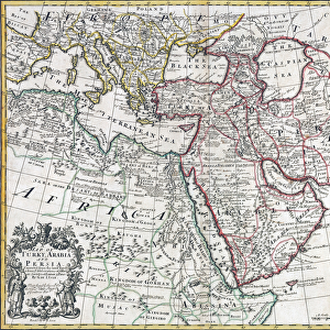
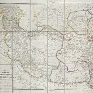
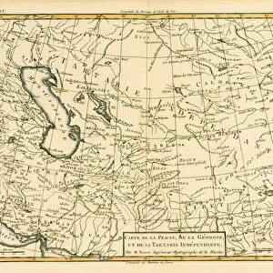
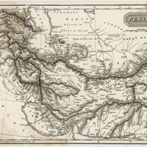
New and accurate map of Persia, with the Safavid and Mughal Empire. Artist: Bowen, Emanuel (c. 1714-1767)
")
![]()
Wall Art and Photo Gifts from Heritage Images
New and accurate map of Persia, with the Safavid and Mughal Empire. Artist: Bowen, Emanuel (c. 1714-1767)
New and accurate map of Persia, with the Safavid and Mughal Empire. Private Collection
Heritage Images features heritage image collections
Media ID 15019244
© Fine Art Images
Bowen Iran Mughal Empire Persia Safavid Empire
FEATURES IN THESE COLLECTIONS
> Arts
> Artists
> B
> Emanuel Bowen
> Asia
> Iran
> Related Images
> Maps and Charts
> Related Images
EDITORS COMMENTS
This print showcases a remarkable piece of cartographic history - the "New and accurate map of Persia, with the Safavid and Mughal Empire". Created by the talented artist Emanuel Bowen in the mid-18th century, this exquisite etching offers a glimpse into the intricate political landscape of Persia during that era. The map depicts not only the vast territories of Persia but also highlights two significant empires that shaped its history - the Safavid Empire and the Mughal Empire. The Safavids, known for their rich cultural heritage and influential rule over Iran from 1501 to 1736, are represented by their extensive dominions. Meanwhile, the Mughals' presence is illustrated through their empire's reach into parts of present-day India, Pakistan, Afghanistan, and Bangladesh. With meticulous attention to detail and precision in his craft, Bowen captures both geographical accuracy and historical significance in this fine art piece. It serves as a valuable resource for scholars studying Persian history or anyone fascinated by ancient civilizations. Preserved within a private collection today, this extraordinary map invites viewers to embark on a visual journey back in time. As we admire its delicate lines and intricate patterns, we can't help but marvel at how it encapsulates centuries-old stories of conquests, alliances, trade routes, and cultural exchanges between these mighty empires. Through this print from Heritage Images comes an opportunity to appreciate not just artistry but also gain insights into our shared human past – where borders shifted like
MADE IN THE USA
Safe Shipping with 30 Day Money Back Guarantee
FREE PERSONALISATION*
We are proud to offer a range of customisation features including Personalised Captions, Color Filters and Picture Zoom Tools
SECURE PAYMENTS
We happily accept a wide range of payment options so you can pay for the things you need in the way that is most convenient for you
* Options may vary by product and licensing agreement. Zoomed Pictures can be adjusted in the Cart.