Home > Europe > United Kingdom > Wales > Maps
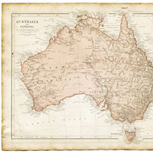
Old engraved map of Sydney (capital city of the state of New South Wales, Australia) and Port Jackson
 and Port Jackson")
![]()
Wall Art and Photo Gifts from Australian Views
Old engraved map of Sydney (capital city of the state of New South Wales, Australia) and Port Jackson
Copyright has expired on this artwork. From my own archives, digitally restored
Unveiling the Splendour of Australia through Exquisite Artwork
mikroman6
2030185337
Media ID 36101685
© 2014-2024 Tomasz Skoczen
FEATURES IN THESE COLLECTIONS
> Australian Views
> Australia's Rich History
> Europe
> United Kingdom
> Wales
> Maps
> Europe
> United Kingdom
> Wales
> Posters
> Europe
> United Kingdom
> Wales
> Related Images
> Maps and Charts
> Related Images
> Maps and Charts
> Wales
> Oceania
> Australia
> Related Images
> Oceania
> Australia
> Sydney
EDITORS COMMENTS
This old engraved map, titled "A Correct and Accurate Chart of the Harbour of Sydney in New South Wales," is a fascinating glimpse into the historical development of Sydney, the iconic capital city of the Australian state of New South Wales. The map, created in the late 18th century, showcases Port Jackson, the natural harbor that has played a pivotal role in Sydney's growth and prosperity. The intricate details of the map reveal the early European settlements, including the site of the first British colony in 1788, and the names of various bays, coves, and headlands. The map also highlights the rich natural resources of the area, such as the abundant fish and oysters in the harbor, and the forests and agricultural lands beyond. The map's intricate engravings and meticulous attention to detail provide a window into the past, allowing us to imagine the lives of the early settlers and the challenges they faced in establishing a new community in a foreign land. The map also serves as a reminder of the importance of maritime exploration and cartography in shaping our understanding of the world and the places we call home. This map, copyright has expired, is part of the extensive collection of Australian historical maps and views by mikroman6 from the Australian Views archive. Through careful digitization and restoration, the intricacies and historical significance of this map have been preserved for future generations to appreciate and learn from.
MADE IN THE USA
Safe Shipping with 30 Day Money Back Guarantee
FREE PERSONALISATION*
We are proud to offer a range of customisation features including Personalised Captions, Color Filters and Picture Zoom Tools
SECURE PAYMENTS
We happily accept a wide range of payment options so you can pay for the things you need in the way that is most convenient for you
* Options may vary by product and licensing agreement. Zoomed Pictures can be adjusted in the Cart.