Home > Arts > Photorealistic artworks > Detailed art pieces > Masterful detailing in art
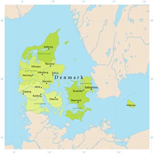
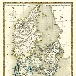
Old Map of Denmark 1852 by Henry George Collins

![]()
Wall Art and Photo Gifts from MapSeeker
Old Map of Denmark 1852 by Henry George Collins
This is a finely detailed map of Denmark remastered from a rare Atlas of the World published in 1852 by Henry George Collins. Although these Henry Collins produced maps of the highest quality in his time unfortunately not the same could be said in terms of his business success. His maps were later obtained by the famous Stanford Map Company and used in their publications
Welcome to the Mapseeker Image library and enter an historic gateway to one of the largest on-line collections of Historic Maps, Nostalgic Views, Vista's and Panorama's from a World gone by.
Media ID 20347076
© Mapseeker Publishing Ltd
Collins Collins Atlas Collins Atlas Map Collins Map
FEATURES IN THESE COLLECTIONS
> Arts
> Photorealistic artworks
> Detailed art pieces
> Masterful detailing in art
> Europe
> Denmark
> Related Images
> Maps and Charts
> Related Images
> Maps and Charts
> World
> MapSeeker
> Maps of Europe
> Maps of Scandinavia PORTFOLIO
EDITORS COMMENTS
This beautifully preserved print showcases an exquisite piece of cartographic history - the "Old Map of Denmark 1852" by Henry George Collins. Remastered from a rare Atlas of the World published in the same year, this map offers a glimpse into Denmark's past with its intricate details and meticulous craftsmanship. Henry George Collins was renowned for his exceptional map-making skills during his time, ensuring that each map he produced was of the highest quality. However, despite his talent, he faced challenges in terms of business success. Fortunately, his remarkable maps found their way into the hands of the prestigious Stanford Map Company, who recognized their value and incorporated them into their own publications. The "Old Map of Denmark 1852" is not just a visual representation but also a testament to Collins' dedication to accuracy and precision. Every contour line, river course, and city placement has been carefully plotted on this vintage Danish map. It serves as a window to explore how Denmark appeared over 150 years ago - its borders intact yet subtly different from what we know today. Whether you are an avid collector or simply fascinated by historical geography, this old Danish map will transport you back in time and allow you to appreciate both Henry George Collins' artistic prowess and Denmark's rich heritage.
MADE IN THE USA
Safe Shipping with 30 Day Money Back Guarantee
FREE PERSONALISATION*
We are proud to offer a range of customisation features including Personalised Captions, Color Filters and Picture Zoom Tools
SECURE PAYMENTS
We happily accept a wide range of payment options so you can pay for the things you need in the way that is most convenient for you
* Options may vary by product and licensing agreement. Zoomed Pictures can be adjusted in the Cart.