Home > Europe > United Kingdom > England > London > Boroughs > Barnet
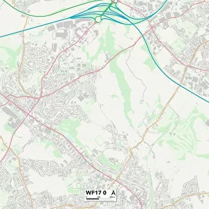
Hertsmere WD6 2 Map

![]()
Wall Art and Photo Gifts from Map Marketing
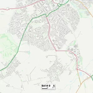
Hertsmere WD6 2 Map
Postcode Sector Map of Hertsmere WD6 2
Media ID 19982950
Ashley Drive Balmoral Drive Brownlow Road Buckingham Road Byron Avenue Carlton Close Carrington Avenue Carrington Close Cedars Close Chaucer Grove Clydesdale Close Coleridge Way Drayton Road Dunnock Close Farriers Way Hampton Close Hertsmere Howard Drive Hunter Close Keats Close Kipling Way Lincoln Court Masefield Avenue Melrose Avenue Milton Drive Norfolk Gardens Richmond Close Ripon Way Rye Close Saddlers Close Sandringham Close Shakespeare Drive Shelley Close Shetland Close Siskin Close St Pauls Close Station Road Stirling Way Suffolk Close Vale Avenue Whitehall Close
FEATURES IN THESE COLLECTIONS
> Animals
> Birds
> Passerines
> Accentors
> Dunnock
> Europe
> United Kingdom
> England
> Cleveland
> Europe
> United Kingdom
> England
> London
> Boroughs
> Barnet
> Europe
> United Kingdom
> England
> London
> Boroughs
> Hackney
> Europe
> United Kingdom
> England
> London
> Sights
> Richmond Park
> Europe
> United Kingdom
> England
> Norfolk
> Drayton
> Europe
> United Kingdom
> England
> Norfolk
> Easton
> Europe
> United Kingdom
> England
> Norfolk
> Newton
> Europe
> United Kingdom
> England
> Norfolk
> Related Images
> Europe
> United Kingdom
> England
> Norfolk
> Sandringham
> Map Marketing
> Postcode Sector Maps
> WD - Watford
MADE IN THE USA
Safe Shipping with 30 Day Money Back Guarantee
FREE PERSONALISATION*
We are proud to offer a range of customisation features including Personalised Captions, Color Filters and Picture Zoom Tools
SECURE PAYMENTS
We happily accept a wide range of payment options so you can pay for the things you need in the way that is most convenient for you
* Options may vary by product and licensing agreement. Zoomed Pictures can be adjusted in the Cart.