Home > Europe > United Kingdom > Scotland > Edinburgh > Edinburgh
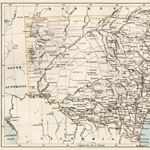
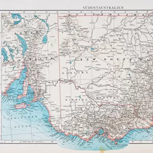
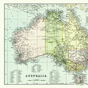
Map of New South Wales and Victoria, 1902. Creator: Unknown

![]()
Wall Art and Photo Gifts from Heritage Images
Map of New South Wales and Victoria, 1902. Creator: Unknown
Map of New South Wales and Victoria, 1902. With inset of Melbourne. From The Century Atlas of the World. [John Walker & Co, Ltd. London, 1902]
Heritage Images features heritage image collections
Media ID 15512306
© The Print Collector / Heritage-Images
Australia Coastline Edinburgh Geographical Institute New South Wales Victoria
FEATURES IN THESE COLLECTIONS
> Europe
> United Kingdom
> Scotland
> Edinburgh
> Edinburgh
> Europe
> United Kingdom
> Scotland
> Lothian
> Edinburgh
> Europe
> United Kingdom
> Wales
> Maps
> Europe
> United Kingdom
> Wales
> Posters
> Maps and Charts
> Related Images
> Maps and Charts
> Wales
> Maps and Charts
> World
> Oceania
> Australia
> Melbourne
EDITORS COMMENTS
This print showcases a detailed map of New South Wales and Victoria, dating back to the year 1902. The creator of this historical piece remains unknown, adding an air of mystery and intrigue to its origins. The map is enriched with vibrant colors that bring life to the coastlines and geographical features depicted within. The inclusion of an inset featuring Melbourne further enhances the significance of this print, as it provides a glimpse into the bustling city during that era. As we delve into this snapshot from history, we are transported back in time to witness how these regions appeared over a century ago. The Edinburgh Geographical Institute's expertise is evident in the precision and accuracy displayed on this map. Every detail has been meticulously captured, allowing us to appreciate both the natural beauty and man-made landmarks present at that time. Preserved by The Print Collector, this artifact serves as a testament to their commitment towards safeguarding our heritage for future generations. It reminds us of Australia's rich history while also highlighting advancements made in cartography during the early 20th century. As we gaze upon this remarkable image, let us reflect on how far New South Wales and Victoria have come since then – evolving into thriving states known for their cultural diversity, stunning landscapes, and vibrant cities. This print acts as a window into our past while inspiring curiosity about what lies ahead for these dynamic regions.
MADE IN THE USA
Safe Shipping with 30 Day Money Back Guarantee
FREE PERSONALISATION*
We are proud to offer a range of customisation features including Personalised Captions, Color Filters and Picture Zoom Tools
SECURE PAYMENTS
We happily accept a wide range of payment options so you can pay for the things you need in the way that is most convenient for you
* Options may vary by product and licensing agreement. Zoomed Pictures can be adjusted in the Cart.