Home > Europe > United Kingdom > Scotland > Edinburgh > Edinburgh
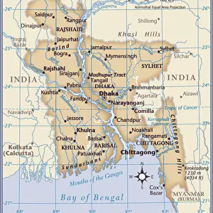
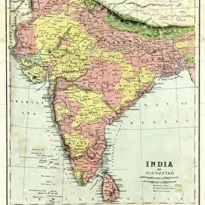
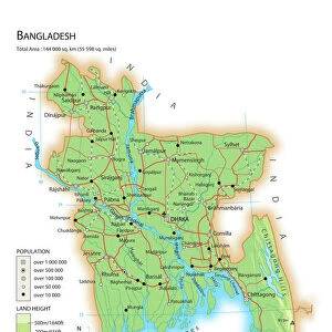
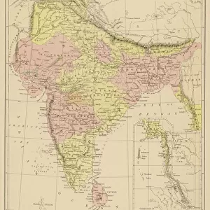
Map of Bengal, the North West and Central Provinces, and Assam, 1902. Creator: Unknown

![]()
Wall Art and Photo Gifts from Heritage Images
Map of Bengal, the North West and Central Provinces, and Assam, 1902. Creator: Unknown
Map of Bengal, the North West and Central Provinces, and Assam, 1902. From The Century Atlas of the World. [John Walker & Co, Ltd. London, 1902]
Heritage Images features heritage image collections
Media ID 15512300
© The Print Collector / Heritage-Images
Bangladesh Bay Of Bengal Bengal British Raj Edinburgh Geographical Institute Indian Ocean The Raj Assam British Empire
FEATURES IN THESE COLLECTIONS
> Arts
> Artists
> O
> Oceanic Oceanic
> Asia
> Bangladesh
> Maps
> Asia
> Bangladesh
> Related Images
> Asia
> India
> Related Images
> Europe
> United Kingdom
> Scotland
> Edinburgh
> Edinburgh
> Europe
> United Kingdom
> Scotland
> Lothian
> Edinburgh
> Maps and Charts
> British Empire Maps
> Maps and Charts
> India
> Maps and Charts
> Related Images
EDITORS COMMENTS
This print showcases a historical treasure - the Map of Bengal, the North West and Central Provinces, and Assam from 1902. Created by an unknown artist, this map offers a fascinating glimpse into the intricate geography of Asia during the early 20th century. The vibrant colors used in this print bring to life the vast territories that were part of British India at that time. From Assam in the east to Bengal in the west, this map covers a wide expanse of land that includes present-day India and Bangladesh. The Bay of Bengal and Indian Ocean are also prominently featured, reminding us of these regions' strategic importance for trade routes. As we explore this detailed map, we can imagine how it would have been utilized during its era. It served as an essential tool for understanding boundaries within British India's administrative divisions known as provinces. This particular edition was published by John Walker & Co Ltd. , based in London. Preserved through time by The Century Atlas of World publication, this print is now brought back to life thanks to The Print Collector's efforts. Its inclusion in Heritage Images allows us to appreciate not only its aesthetic value but also its historical significance.
MADE IN THE USA
Safe Shipping with 30 Day Money Back Guarantee
FREE PERSONALISATION*
We are proud to offer a range of customisation features including Personalised Captions, Color Filters and Picture Zoom Tools
SECURE PAYMENTS
We happily accept a wide range of payment options so you can pay for the things you need in the way that is most convenient for you
* Options may vary by product and licensing agreement. Zoomed Pictures can be adjusted in the Cart.