Home > Europe > United Kingdom > England > Durham > Easington
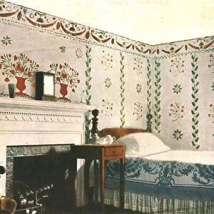
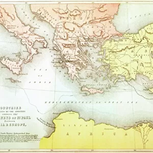
Chart showing windmills as landmarks on the north-east coast of England, 1588, (1947)
")
![]()
Wall Art and Photo Gifts from Heritage Images
Chart showing windmills as landmarks on the north-east coast of England, 1588, (1947)
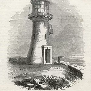
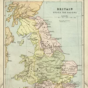
Chart showing windmills as landmarks on the north-east coast of England, 1588, (1947). Places marked include Hartlepool, Easington and Sunderland. Detail from " The Mariners Mirrour" by Anthony Ashley, an English translation of the worlds first sea-atlas by Lucas Janszoon Waghenaer. From " British Windmills and Watermills, by C. P. Skilton. [Collins, London, 1947]
Heritage Images features heritage image collections
Media ID 19777832
© The Print Collector/Heritage Images
Britain In Pictures Chart Coat Of Arms Collins Durham Heraldic Heraldry Landmark Navigation Social History Sunderland Tyne And Wear William Collins William Collins And Sons William Collins Sons Windmill Windmills Easington Hartlepool Lukas Skilton
FEATURES IN THESE COLLECTIONS
> Animals
> Mammals
> Muridae
> Fortior
> Arts
> Artists
> C
> Charles Collins
> Arts
> Artists
> C
> William Charles
> Arts
> Artists
> C
> William Collins
> Europe
> United Kingdom
> England
> Durham
> Durham
> Europe
> United Kingdom
> England
> Durham
> Easington
> Europe
> United Kingdom
> England
> Durham
> Hartlepool
> Europe
> United Kingdom
> England
> Durham
> Sunderland
> Europe
> United Kingdom
> England
> Maps
> Europe
> United Kingdom
> England
> Sunderland
EDITORS COMMENTS
This print showcases a detailed chart from 1588, revealing windmills as prominent landmarks along the picturesque north-east coast of England. The image, taken from "The Mariners Mirrour" by Anthony Ashley, offers a glimpse into the world's first sea-atlas created by Lucas Janszoon Waghenaer. The chart highlights significant locations such as Hartlepool, Easington, and Sunderland with their distinctive windmills serving as beacons for sailors navigating these treacherous waters. The vibrant colors and intricate details of this century-old map transport us back in time to an era when windmills dotted the coastal landscape. It is fascinating to observe how these structures played a crucial role not only in milling grain but also in aiding navigation for seafarers. As we delve into history through this remarkable print, we are reminded of the rich heritage that defines Britain's coastal regions. This piece serves as a testament to the enduring legacy of windmills and their significance within English culture. Preserved within the pages of "British Windmills and Watermills" by C. P. Skilton and published by Collins in 1947, this print allows us to appreciate both its historical value and artistic beauty. Let it serve as a window into our past—a reminder of how landmarks like windmills have shaped our social history while standing proudly against the backdrop of England's stunning coastline.
MADE IN THE USA
Safe Shipping with 30 Day Money Back Guarantee
FREE PERSONALISATION*
We are proud to offer a range of customisation features including Personalised Captions, Color Filters and Picture Zoom Tools
SECURE PAYMENTS
We happily accept a wide range of payment options so you can pay for the things you need in the way that is most convenient for you
* Options may vary by product and licensing agreement. Zoomed Pictures can be adjusted in the Cart.