Home > Granger Art on Demand > Maps
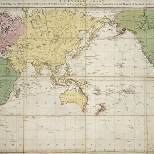
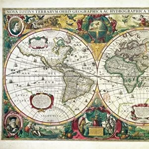
CAPTAIN COOK: MAP, 1808. English double hemisphere map, 1808, by Laurie

![]()
Wall Art and Photo Gifts from Granger
CAPTAIN COOK: MAP, 1808. English double hemisphere map, 1808, by Laurie
CAPTAIN COOK: MAP, 1808. English double hemisphere map, 1808, by Laurie and Whittle recording all the voyages of Captain James Cook
Granger holds millions of images spanning more than 25,000 years of world history, from before the Stone Age to the dawn of the Space Age
Media ID 6617075
1770s 1808 Captain Cook Explorer South Pacific World
EDITORS COMMENTS
This print showcases a remarkable piece of history - the "CAPTAIN COOK: MAP, 1808". Created by Laurie and Whittle, this English double hemisphere map from 1808 meticulously documents all the voyages undertaken by the legendary explorer Captain James Cook. The map takes us back to an era when exploration was at its peak, offering a glimpse into the world as it was known in the late 18th century. With intricate details and precision, it highlights Cook's extensive journeys across uncharted territories in search of new lands and discoveries. As we study this fascinating artwork, we are transported to distant shores where Cook left his indelible mark. From the vast South Pacific to remote river systems, every corner of these maps tells a story of adventure and bravery. Captain James Cook's expeditions were instrumental in expanding our understanding of geography and opening up new trade routes. His contributions shaped our knowledge about different cultures and natural wonders that were previously unknown. This print is not just a visual delight but also serves as a testament to human curiosity and exploration. It reminds us of the courage required to venture into unexplored territories for the pursuit of knowledge. With its historical significance and artistic beauty, this "CAPTAIN COOK: MAP, 1808" print from The Granger Collection is sure to captivate anyone with an appreciation for early exploration or those seeking inspiration from one man's relentless quest for discovery.
MADE IN THE USA
Safe Shipping with 30 Day Money Back Guarantee
FREE PERSONALISATION*
We are proud to offer a range of customisation features including Personalised Captions, Color Filters and Picture Zoom Tools
SECURE PAYMENTS
We happily accept a wide range of payment options so you can pay for the things you need in the way that is most convenient for you
* Options may vary by product and licensing agreement. Zoomed Pictures can be adjusted in the Cart.