Home > Arts > Street art graffiti > Digital art > Vector illustrations
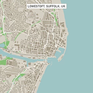
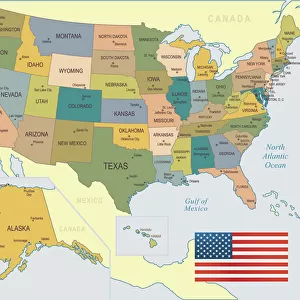
Fontana California US City Street Map

![]()
Wall Art and Photo Gifts from Fine Art Storehouse
Fontana California US City Street Map
Vector Illustration of a City Street Map of Fontana, California, USA. Scale 1:60, 000.
All source data is in the public domain.
U.S. Geological Survey, US Topo
Used Layers:
USGS The National Map: National Hydrography Dataset (NHD)
USGS The National Map: National Transportation Dataset (NTD)
Unleash your creativity and transform your space into a visual masterpiece!
Frank Ramspott
Media ID 15055139
© Frank Ramspott, all rights reserved
Aerial View California City Map Computer Graphic Directly Above Downtown District Fontana Gray Road Map Text Digitally Generated Image Green Color White Color
FEATURES IN THESE COLLECTIONS
> Aerial Photography
> Related Images
> Animals
> Insects
> Hemiptera
> Green Scale
> Animals
> Mammals
> Cricetidae
> California Mouse
> Arts
> Contemporary art
> Digital artwork
> Street art
> Arts
> Landscape paintings
> Waterfall and river artworks
> River artworks
> Arts
> Portraits
> Pop art gallery
> Street art portraits
> Arts
> Street art graffiti
> Digital art
> Digital paintings
> Arts
> Street art graffiti
> Digital art
> Vector illustrations
> Fine Art Storehouse
> Map
> Street Maps
> Fine Art Storehouse
> Map
> USA Maps
> Maps and Charts
> Geological Map
> Maps and Charts
> Related Images
EDITORS COMMENTS
This print showcases a detailed and visually stunning city street map of Fontana, California, USA. The vector illustration captures the essence of this vibrant city with its downtown district, river, lake, and intricate network of streets. With a scale of 1:60,000, every nook and cranny is meticulously depicted. The source data for this artwork is in the public domain and has been sourced from the U. S. Geological Survey's National Map. The layers used include the National Hydrography Dataset (NHD) and the National Transportation Dataset (NTD), ensuring accuracy in portraying water bodies and transportation routes. Designed by Frank Ramspott using computer graphics technology, this digitally generated image offers an aerial view directly above Fontana. The color palette features shades of gray, green, blue, and white to represent different elements on the map. With no people present in the image itself, all attention is drawn to the intricacies of Fontana's physical geography as portrayed through cartography. This print serves as both a functional road map for navigation purposes and an artistic representation that highlights the beauty found within urban landscapes.
MADE IN THE USA
Safe Shipping with 30 Day Money Back Guarantee
FREE PERSONALISATION*
We are proud to offer a range of customisation features including Personalised Captions, Color Filters and Picture Zoom Tools
SECURE PAYMENTS
We happily accept a wide range of payment options so you can pay for the things you need in the way that is most convenient for you
* Options may vary by product and licensing agreement. Zoomed Pictures can be adjusted in the Cart.