Home > Animals > Mammals > Cats (Wild) > Tiger
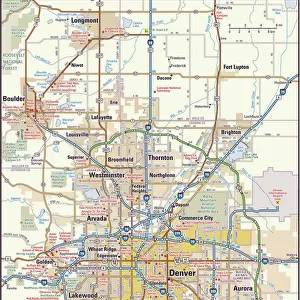
CT Fairfield Easton Vector Road Map

![]()
Wall Art and Photo Gifts from Fine Art Storehouse
CT Fairfield Easton Vector Road Map
CT Fairfield Easton Vector Road Map. All source data is in the public domain. U.S. Census Bureau Census Tiger. Used Layers: areawater, linearwater, roads, rails, cousub, pointlm, uac10
Unleash your creativity and transform your space into a visual masterpiece!
Frank Ramspott
Media ID 20688311
© Frank Ramspott, all rights reserved
City Map Computer Graphic Connecticut County Digital Composite District Fairfield Geographical Border Road Map Text Vector Digitally Generated Image Easton Redding Stepney
FEATURES IN THESE COLLECTIONS
> Animals
> Mammals
> Cats (Wild)
> Tiger
> Animals
> Mammals
> Muridae
> Plains Mouse
> Animals
> Mammals
> Muridae
> Water Mouse
> Arts
> Contemporary art
> Digital artwork
> Pop art
> Arts
> Contemporary art
> Digital artwork
> Street art
> Arts
> Contemporary art
> Pop art
> Digital art
> Arts
> Landscape paintings
> Waterfall and river artworks
> River artworks
> Arts
> Still life artwork
> Pop art
> Digital art
> Arts
> Modern art pieces
> Pop art
> Street art
> Fine Art Storehouse
> Map
> Reference Maps
EDITORS COMMENTS
This print showcases the intricate details of the CT Fairfield Easton Vector Road Map. Designed and digitally generated by Frank Ramspott, this visually stunning image is a testament to the artistry of cartography. With its vibrant colors and precise lines, it brings to life the geographical borders, cities, towns, rivers, lakes, and roads that make up this region. The map draws from public domain data provided by the U. S. Census Bureau Census Tiger and incorporates various layers such as areawater, linearwater, roads, rails, cousub (county subdivisions), pointlm (landmarks), and uac10 (urban areas). Every element has been meticulously crafted to create a comprehensive representation of Fairfield County's road network. In this composition devoid of people but rich in detail, one can explore key landmarks like Twin Bridges, Stepney, Sanfordtown or Redding while traversing through Staples Hill or Flirt Hill. The towns of Plattsville and Pop Mountain also find their place on this map alongside Aspetuck and Lyons Plain. Whether you're an avid traveler seeking new destinations or simply appreciate fine cartographic artistry at its best - this color image will undoubtedly captivate your imagination. Its vector format ensures sharpness even when zoomed in closely while adding a touch of modernity to any space it adorns. A true masterpiece for those who admire both design excellence and physical geography!
MADE IN THE USA
Safe Shipping with 30 Day Money Back Guarantee
FREE PERSONALISATION*
We are proud to offer a range of customisation features including Personalised Captions, Color Filters and Picture Zoom Tools
SECURE PAYMENTS
We happily accept a wide range of payment options so you can pay for the things you need in the way that is most convenient for you
* Options may vary by product and licensing agreement. Zoomed Pictures can be adjusted in the Cart.