Home > Maps and Charts > British Empire Maps
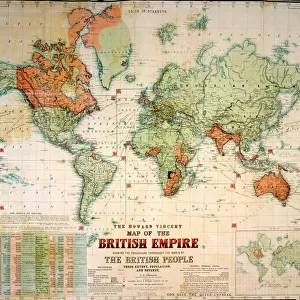
Antique Commercial Map of the World

![]()
Wall Art and Photo Gifts from Fine Art Storehouse
Antique Commercial Map of the World
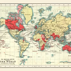
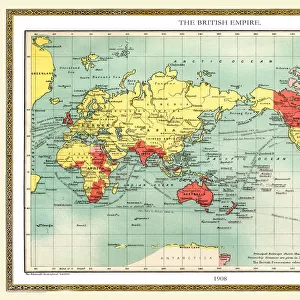
Antique Commercial Map of the World from 1891. Showing the British Empire in Red
Unleash your creativity and transform your space into a visual masterpiece!
duncan1890
Media ID 20172645
© duncan1890
Asia Pac Commonwealth Of Independent States
FEATURES IN THESE COLLECTIONS
> Fine Art Storehouse
> Map
> Historical Maps
> Maps and Charts
> British Empire Maps
> Maps and Charts
> Related Images
> Maps and Charts
> World
EDITORS COMMENTS
This print takes us back in time to the year 1891, showcasing an exquisite Antique Commercial Map of the World. The map is a true testament to the artistry and precision of cartography during that era. As our eyes wander across its intricate details, we are immediately drawn to the vibrant red hue that highlights the vast territories of the British Empire. The map offers a fascinating glimpse into a bygone era when colonial powers held sway over large parts of the globe. It invites us to explore and trace their dominion through continents and oceans, from Asia Pacific to Commonwealth of Independent States. Every line and curve on this vintage masterpiece tells stories of exploration, conquests, trade routes, and cultural exchanges. Duncan1890's expertly captured photograph allows us to appreciate not only the historical significance but also the aesthetic beauty inherent in this antique piece. The sepia tones add an extra layer of nostalgia, transporting us back in time as if we were holding this very map ourselves. Whether you are a history enthusiast or simply captivated by vintage charm, this print will undoubtedly make for an intriguing addition to any space. Let it serve as a reminder of how our world has evolved over centuries while honoring those who came before us – explorers who ventured into uncharted territories with nothing more than maps like these as their guideposts.
MADE IN THE USA
Safe Shipping with 30 Day Money Back Guarantee
FREE PERSONALISATION*
We are proud to offer a range of customisation features including Personalised Captions, Color Filters and Picture Zoom Tools
SECURE PAYMENTS
We happily accept a wide range of payment options so you can pay for the things you need in the way that is most convenient for you
* Options may vary by product and licensing agreement. Zoomed Pictures can be adjusted in the Cart.