Home > Fine Art Storehouse > The Magical World of Illustration > Palmer Illustrated Collection
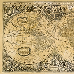
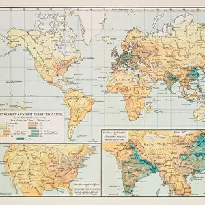
The world in hemispheres map 1875

![]()
Wall Art and Photo Gifts from Fine Art Storehouse
The world in hemispheres map 1875
The Independent Course Comprehensive Geography by James Monteith, A.S. Barnes & Co, New York & Chicago 1875
Unleash your creativity and transform your space into a visual masterpiece!
THEPALMER
Media ID 13612173
© This content is subject to copyright
Eastern Hemisphere Globe Navigational Equipment Hemisphere Paper Planet Earth World Map
FEATURES IN THESE COLLECTIONS
> Fine Art Storehouse
> The Magical World of Illustration
> Palmer Illustrated Collection
> Fine Art Storehouse
> Map
> Historical Maps
> Fine Art Storehouse
> Map
> USA Maps
The World in Hemispheres Map 1875
EDITORS COMMENTS
takes us on a captivating journey back in time, offering a glimpse into the intricate art of cartography from over a century ago. This exquisite print, sourced from "The Independent Course Comprehensive Geography" by James Monteith, showcases the immense skill and attention to detail that went into creating such navigational masterpieces. As we gaze upon this vintage treasure, we are transported to an era when paper maps were cherished possessions and globe navigational equipment was revered for its accuracy. The engraving technique used to produce this image adds an air of elegance and nostalgia, reminding us of the craftsmanship that once defined mapmaking. With its rich hues and delicate lines, this antique illustration beautifully captures both the physical geography and cultural diversity of our planet Earth. Divided into eastern hemispheres, it invites us to explore continents long past their colonial days and oceans teeming with undiscovered wonders. "The World in Hemispheres Map 1875" is not just a piece of art; it is a testament to human curiosity and our unending quest for knowledge. It serves as a reminder that even as technology advances at breakneck speed, there will always be something enchanting about holding an old map in our hands – tracing ancient routes with our fingers while marveling at how far we have come. This print by THEPALMER is truly a collector's delight – perfect for history enthusiasts or anyone seeking inspiration from the past.
MADE IN THE USA
Safe Shipping with 30 Day Money Back Guarantee
FREE PERSONALISATION*
We are proud to offer a range of customisation features including Personalised Captions, Color Filters and Picture Zoom Tools
SECURE PAYMENTS
We happily accept a wide range of payment options so you can pay for the things you need in the way that is most convenient for you
* Options may vary by product and licensing agreement. Zoomed Pictures can be adjusted in the Cart.