Home > Animals > Mammals > Soricidae > Navigator
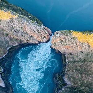
Mitchell River - Queensland

![]()
Wall Art and Photo Gifts from Australian Views
Mitchell River - Queensland
This aerial photo shows the middle reaches of the Mitchell River located in Far North Queensland, Australia. The river rises on the Atherton Tableland about 50 kilometres northwest of Cairns, and flows about 750 kilometres northwest across Cape York Peninsula from Mareeba to the Gulf of Carpentaria. The rivers watershed covers an area of 71, 757 km2. The Mitchell River has the states largest discharge at 11.3 million megalitres annually, but is intermittent and may be dry for part of the year. It was named by Ludwig Leichhardt on 16 June 1845 after Sir Thomas Mitchell while he was on his overland expedition from Moreton Bay to Port Essington. It may have been previously named the Vereenighde River in 1623 by a Dutch merchant and navigator, Jan Carstensz. The Mitchell River and its tributaries have for a long time carved their way westwards through the rugged, weathered highlands of the Great Dividing Range, carrying away sediments to be deposited in the broad floodplains and wetlands of the Gulf Savannah country. The rivers waters pulse annually with monsoonal rains, seasonally collecting water from across the local tropical rainforests in the highlands to the east; the wet sclerophyll forests in the central uplands; a variety of woodlands plus savannah in the western plains; annually flooding with freshwater, the tidal plains, wetlands, estuaries, and mangroves of the lower Mitchell and coastal plains. From source to mouth, the Mitchell River is joined by 34 tributaries including the McLeod River, Hodgkinson River, St George River, Dry River, Little Mitchell River, Walsh River, Lynd River, Palmer River and Alice River
Unveiling the Splendour of Australia through Exquisite Artwork
Photography by Mangiwau
Mitchell River - Queensland
Media ID 14788137
© 2015 Michael Thirnbeck
FEATURES IN THESE COLLECTIONS
> Aerial Photography
> Australia
> Animals
> Mammals
> Soricidae
> Navigator
> Australian Views
> Aerial Views
> Europe
> United Kingdom
> Scotland
> Highlands
> Related Images
> Oceania
> Australia
> Related Images
EDITORS COMMENTS
This stunning aerial photo captures the majestic Mitchell River, located in Far North Queensland, Australia. Spanning across Cape York Peninsula, this river stretches about 750 kilometers from Mareeba to the Gulf of Carpentaria. With a watershed covering an impressive area of 71,757 square kilometers, it is no wonder that the Mitchell River boasts the largest discharge in the state at 11.3 million megalitres annually. Named after Sir Thomas Mitchell by Ludwig Leichhardt during his overland expedition in 1845, this waterway has a rich history dating back even further. It may have been previously known as the Vereenighde River by Dutch merchant and navigator Jan Carstensz in 1623. The Mitchell River and its tributaries have carved their way through the rugged highlands of the Great Dividing Range for centuries, leaving behind breathtaking floodplains and wetlands in what is now known as Gulf Savannah country. The river's waters ebb and flow with monsoonal rains each year, collecting water from tropical rainforests to woodlands before flooding into estuaries and mangroves along its path. This mesmerizing print showcases not only the natural beauty of Queensland but also highlights our planet's intricate hydrological systems. Photography by Mangiwau beautifully captures this awe-inspiring landscape for all to admire and appreciate.
MADE IN THE USA
Safe Shipping with 30 Day Money Back Guarantee
FREE PERSONALISATION*
We are proud to offer a range of customisation features including Personalised Captions, Color Filters and Picture Zoom Tools
SECURE PAYMENTS
We happily accept a wide range of payment options so you can pay for the things you need in the way that is most convenient for you
* Options may vary by product and licensing agreement. Zoomed Pictures can be adjusted in the Cart.